Point Cloud Generation
A 3D laser scan survey is taken of the existing site to begin the design process, enabling our designers to ensure that the proposed works will accurately fit within the existing footprint. The lasers scans have minimal interference with any existing works and otherwise normally inaccessible area such as high level or elevated details are easily scanned from the ground level.
Laser Scanning
Once the onsite laser survey has been completed, the raw laser scan data is processed to generate a Point Cloud to be used during the design stage to create a full 3D CAD model. The tolerances of the Point Cloud are within +/- 2mm over 70m.

Scan to CAD Model
Using AutoCAD Plant 3D our engineers work with the client to understand their unique requirements and specifications to produce an accurate 3D CAD model and Navisworks file of existing arrangements with new equipment added. The client can then view the design remotely, take measurements and have a walk-through without leaving their office.
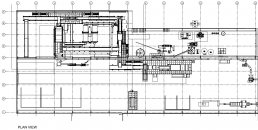
Orthographic/2D Drawing Production
Using the details from the 3D model, 2D drawings can be exported including orthographic, general arrangement layouts and piping isometrics.A traditional GA can be produced with plans & elevations (if required) and annotated with relevant details as required by the client.